Thar be storms a brewin’
📣 We have turned south 📣 I know at least some of y'all have been like "I'm here for ice content and instead they've been hanging out around Australia for days" and I promise you *we know and we all feel the same way*.
Because we're a US government ship, our captain gets route recommendations from the US navy that balance where we want to go with weather and other safety info. We've been avoiding a big storm between us and Antarctica and now we're diving down to the continent before another storm can come through.
These storms are par for the course down here, and they're part of what makes Antarctica special. There's an unbroken loop of ocean around the continent with no land to block wind or waves from hammering a ship like ours, or like the explorers in ye olden days who had so many shipwrecks trying to get to Antarctica.
What we see on the surface is reflected in the ocean- the circumpolar current here is the largest and fastest in the world, and it's kept Antarctic ocean life isolated for tens of millions of years. Which makes them special and important to understand and is why we're here!
- Your question: "What does 'hiding in the ice' mean?" I said a few days ago that the crossing will take a week and then we can hide in the ice from more storms. I mean that icebergs and ice on the water's surface dampen waves so we will get a much smoother ride, and we can tuck in behind ice shelves (the ice cliffs you see in pictures) to get out of the wind if things ever get really bad. A seasick crew can't do science, so the calm of being near the continent is the only way an expedition like ours can work.
🧭 Virginia

Our path and the storms we're darting between. The pointy part of the mouse is the front of our ship, and the tail is the path we took to get here. We started on the east side of the south island and curved around New Zealand's southern end, then shot straight west to at least get us near the longitude of our first sampling spot. We turned south this morning, to come down the back side of that big swirling storm on the right. The blue-purple in the middle of that swirl is 50 - 60 knot winds (almost 60 mph).
See wind data for yourself at https://www.windy.com/ and track our position live at https://www.marinetraffic.com/en/ais/home/shipid:426075/zoom:13
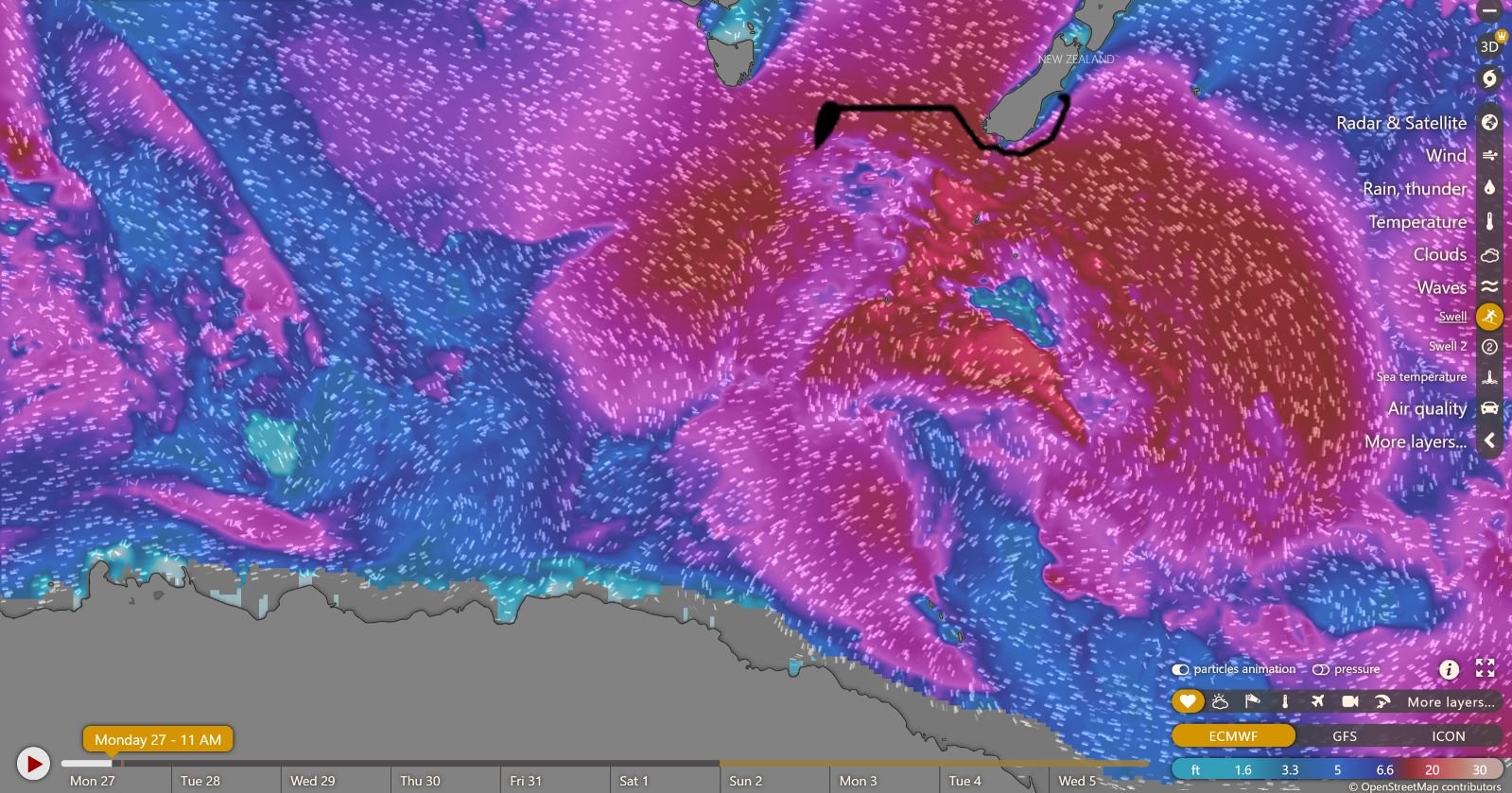
Our path and the swell data for those same storms. Think of waves as the curls at the top of the water, and swells as the big bumps that come across the ocean in long lines. Swells are really what make us seasick. The swells are around 12-15 ft right now, but look how they're more like 25 in that storm and they're not in long, organized lines- they're coming from all directions, like sloshy water in a tub someone's carrying.
And as for "hiding in the ice"- see how swell heights are very, very low right on the Antarctic coast, even though the previous picture shows you that it's still windy there? : )
https://www.windy.com/ shows you a video of wind, wave, and swell movement by moving the little cartoon lines you see all over this picture- it's a great tool to use to see what we're going through.